一枚の特選フォト「海 & 船」
One Selected Photo "Oceans & Ships"
Back to: Top Page |
沖ノ鳥島の北小島・南小島 (縦断面図)
1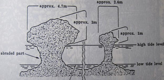
2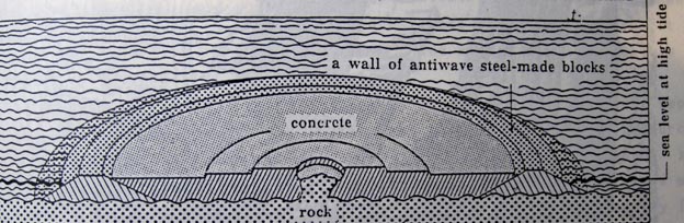
3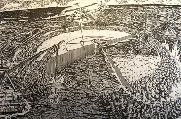
同島において高潮時海面から露出しているのは、2つの自然の小岩 (upheaved limestones) だけである。一つは横幅4.7m、高さ3m。 もう一つは横幅2.6m、高さ1mである。二岩はマッシュルーム形をしている。 政府は、先ずは、1977年7月1日施行の「Law on Privisional Measures Relating to the Fishing Zone」によって、その領海基線から 200海里までの漁業水域を設定した。同水域は、40万km2の面積を有するが、それは日本の国土面積37万平方km2 を上回るものである。 同島の二岩が倒壊して、島が高潮時に海面下に没するようなことになると、現下にあっては、、200海里の経済水域や大陸棚も保持できなくなる。 (1982年国連海洋法条約第121条1-3項には「島」の定義がなされている)。長期的に見て、図2、3にあるような護岩工事による保全措置 はサンゴ礁基盤に悪い影響を与えはしないか危惧される。 中国はその後、沖ノ鳥島は国際海洋法上にいう「島」ではないと主張した。日本はこれに即座に反論した。また、日本は、同島周辺の 大陸棚の一部が200海里以遠に延伸しているとして、その科学的根拠と共に、国連の「大陸棚限界委員会」に申請をしていたところ、 日本の主権が及ぶ延伸大陸棚として認められた。日本は同島が「島」であることが認められていることの証左とする。 今後も中国は島でないことをクレームし続ける可能性がある。クレームに対抗する上でも、「島」の定義にまつわる諸国の事例研究を積み 重ねておくことも重要となろう。中国に同調する国が出現しないとも言いきれない。 さて、政府は緊急措置として、1987年予算年度から岩の周囲に防波堤として直径50mの円形保護壁を造作し、1989年11月に完工した。 画像1-3は、1987~1988年の新聞に掲載された沖の鳥島の岩の断面図、防護壁断面図、その工事予想図である。 |
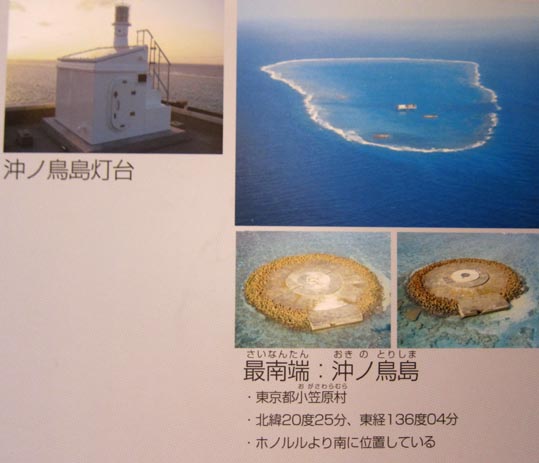
Outlined here is a current focal issue related with a Japan's uninhabited island of coral reef (semi-table reef in terms of topography, ellipse-shaped, about 1.7 km long in diameter and 11 km round at ebb tide(1)) lying in the west Pacific. The island is named "Oki-no-Tori-Shima" in Japanese, which is the Japan's southernmost one (location: 200 25' N. latitude, 1360 05' E. longitude)(2), about 2,000 km south of Tokyo. A crucial issue has been raised as a result of the recent observations made by its competent authorities. That is, only two small rocks (upheaved limestones) lie above sea level at high tide: As shown in attached Figures 1, one rock is merely 4.7 m wide and 3 m high and another is 2.6 m wide and 1 m high.(3) And, both rocks are nowadays mushroom-shaped due to the longstanding abrasions by waves. In accordance with the Law on Privisional Measures Relating to the Fishing Zone, enforced on July 1, 1977, Japan extends its fishery jurisdiction in its surrounding waters up to 200 miles from the baselines from which the territorial seas are measured. The 200-mile fishing zone's jurisdiction in waters surrounding the island is to cover a total area of about 400,000 km2. This maritime zone is considerably larger in area than the total land of the country's own. A most serious issue which the government most fears to occur is: For isntance, if the rocks fell fall down and did not lie above sea level, it would fail to claim its excludive jurisdiction related to not only the continental shelf but a 200-mile exclusive economic zone (EEZ) in waters around them.
Despite such a foreseeable claim of the government, the 1982 UNCLOS provides that: - Rocks which cannot sustain human habitation or economic life of their own shall have no exclusive economic zone or continental shelf (Paragraph 3 of Article 121).
The government has proceeded to an emergency measures for the purpose of territorial integrity since
1987 of Japanese fiscal year (JFY). As shown in attached Figures 2, as one of the planned protection methods,(4) The island's topographical situation in future must be determined principally by the following natural conditions' interaction: rises and falls of not only corals but bedrocks lying beneath them, and abrasion by waves. Thus, another important issue is raised. That is, such a protection or reinforcement measures might have a gravely adverse effect on the island in the long run, i.e. leading it to a submerged sea mount by destroying the corals. [Footnotes](1), (2) and (3): Japanese daily newspaper "Nihon Keizai Shimbun", September 3, 1987. (4) Ibid., November 27, 1987.
The Oki-no-Tori-Shima's rock-protection works having been carried out with a multibillion dollar budget of the Japanese government since the spring of 1988 were eventually accomplished at the beginning of November 1989. If the island is left as it is, there remains nothing but two tiny mushroom-shaped rocks (named "Hokuro-gan" and "Touro-gan") which project their tops several meters above sea level at flood tide. Accordingly, each of the rocks was double-embanked circlewise with heavy steel-made tetrapods totaling 9,900 pieces as a prime measure for protecting them against wave erosion. The total expenditure for the works amounted to \28.5 billion equivalent to more or less US$200 million. Some marine scientific observation-purpose instruments, e.g. tide gauge, were installed on the concrete structures. The neck of each rock had been washed persistently and eroded gradually by waves. Those rock-protection works have been based on the following belief of the gavernment: any legal grounds for justifying its claim over a 200-mile zone around the island, the sea area of which amounts to about 400,000 km2 and is no less than the country's total land area (that is, about 370,000 km2), would be no longer maintained at all if both of them happened to fall down and come to submerge completely at flood tide. Figure: Oki-no-Tori-Shima Island and Protection Measures 1. Section of Two Mushroom-shaped Rocks of Oki-no-Tori-Shima. Source: Japanese daily newspaper, Nihon Keizai Shimbun, September 3, 1987. [拡大画像: x28618.jpg] 2. A Plan of Civil Works for Territorial Integrity of the Oki-no-Tori-Shima Island. Source: Japanese daily newspaper, Asahi Shimbun, November 27, 1987. [拡大画像: x28619.jpg] 3. Asahi Shimbun, June 3, 1988. [拡大画像: x28617.jpg]
|
[参考]
 2 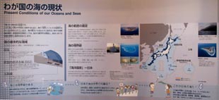 3 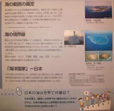
1. 「わが国の海の現状」: [拡大画像: x23652.jpg][拡大画像: x23675.jpg][拡大画像: x23676.jpg][拡大画像: x23677.jpg] 2&3. 「海の範囲の画定」、「海の境界線」、「海洋国家-日本」: [拡大画像: x23673.jpg][拡大画像: x23674.jpg] [画像1&2: 船の科学館訪問&撮影 2011.2.27, 2011.4.28, 2011.8.31] |
Back to: Top Page |