マカオ海事博物館 (1)
Museu Marítimo, Macao
[ 1 ][ 2 ][ 3 ]
[ 4 ][ 5 ][ 6 ]
1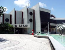 2
2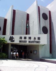 3
3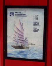 4
4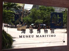
1. 海洋博物館の正面入り口 [拡大画像(x19579.jpg)]
2. 同上 [拡大画像(x19580.jpg)][拡大画像(x19581.jpg): 開館時間など]
3. [拡大画像(x19582.jpg)]
4. [拡大画像(x19583.jpg)]
館内展示風景
1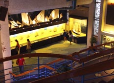 2
2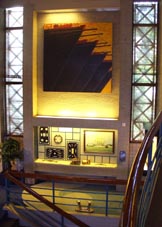 3
3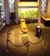
1. いろいろな帆船模型や帆の展示 [拡大画像(x21047.jpg)][拡大画像(x21048.jpg)]
2. [拡大画像(x21049.jpg)][拡大画像(x21066.jpg)]
3. 車輪船の模型 [拡大画像(x21059.jpg)]
4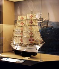 5
5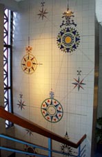 6
6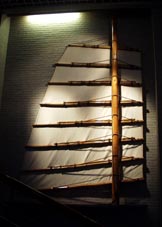 7
7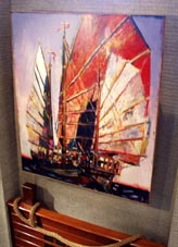
4. [拡大画像(x21061.jpg)]
5. いろいろな方位盤 [拡大画像(x21062.jpg)]
6. 中国独特の帆。帆はいくつものバーで補強されている。 [拡大画像(x21063.jpg)][拡大画像(x21064.jpg)]
7. 中国船の絵画 [拡大画像(x21065.jpg)]
8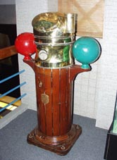 9
9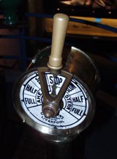 10
10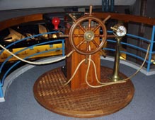
8. 羅針儀 [拡大画像(x21067.jpg)][拡大画像(x21068.jpg)羅針盤]
9. 速度通信器(speed telegraph) [拡大画像(x21069.jpg)]
10. 操舵装置 [拡大画像(x21070.jpg)]
ポルトガルと大航海時代
1 2
2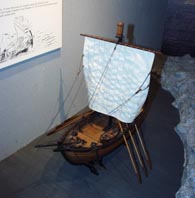 3
3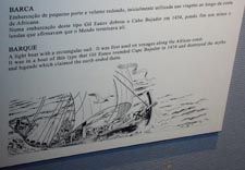 4
4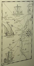
1. [拡大画像(x19702.jpg)]
2. バークの模型([ポルトガル語]Barca, [英語]Barque) [拡大画像(x19703.jpg)][拡大画像(x19704.jpg)]
3. バーク模型の説明では次のように記されている。
「A light boat with a rectangular sail. It was first used on voyages along the African coast.
It was in a boat of this type that Gil Eanes rounded Cape Bojador in 1434 and destroyed the myths
and legends which claimed the earth ended there.」
四角い帆をもつ。アフリカ沿岸航海に最初に用いられた船である。
ジル・イハネス(Gil Eanes)がボハドル岬(Cape Bojador)を1434年に迂回し海はそこで終わっているとの神話・伝説を打ち砕いた。
[拡大画像(x19705.jpg)][拡大画像(x19706.jpg)]
4. 図には、上から「barca」、「caravela」、「nau」の3種類の帆船が描かれている。 [拡大画像(x19707.jpg)]
[拡大画像(x19708.jpg)][拡大画像(x19709.jpg)]
1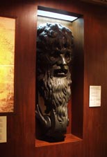 2
2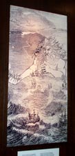 3
3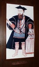 4
4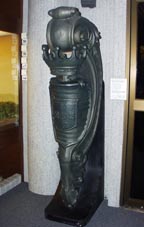
1. アダマストール号の船首像。マカオで1927-1933年にかけて使われていたクルーザー「アダマストール」(海巨人)号
の船首像(複製)。 [拡大画像(x19710.jpg)]
[拡大画像(x19711.jpg): 説明書き]
2. 海の怪物「アダマスター」。海巨人のようなものはアダマスターと呼ばれた。ポルトガルの詩人ルイス・デ・
カモンエスが考案したものである。ポルトガル人探検家とその乗組員たちはアフリカ海岸線を南下することの危険と
伝説上の海の怪物への恐怖と戦いながら、15世紀中にアフリカ海岸線のほとんどを発見した。
[拡大画像(x19712.jpg)][拡大画像(x19713.jpg)]
[拡大画像(x19714.jpg): 説明書き]
3. ポルトガル人海洋探検家バスコ・ダ・ガマ。彼によってヨーロッパ-インド間の海上航路が開かれ、
ポルトガル人が極東まで海路で到達できるようになった。 [拡大画像(x19715.jpg)]
[拡大画像(x19716.jpg)]
4. マカオで1904-1910年にかけて使われた「バスコ・ダ・ガマ号」の船首像(複製)。
[拡大画像(x19717.jpg)][拡大画像(x19718.jpg): 説明書き]
古地図 (館内の英語説明書きによれば、それぞれ下記のように記されている)
1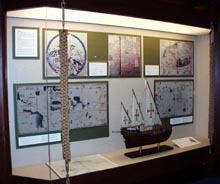 2
2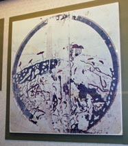 3
3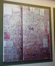 4
4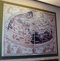
1. Cartography [拡大画像(x19517.jpg)][拡大画像(x19553.jpg)][拡大画像(x19520.jpg): 説明書き]
2. Planisphere of Muhammad Al-Idri'si (Middle 12th Century), showing the Mediterranean Regions。14世紀末頃
まで知られていた世界は地球表面の4分の1くらいで、当時の地図に描かれていたのは輪郭のはっきりした
地域にのみ限定されていた。 [参考]planisphere: 平面球形図; 平面天体図、星座早見表
[拡大画像(x19518.jpg)][拡大画像(x19519.jpg)][拡大画像(x19523.jpg): 説明書き1]
3. Go Tenjiku Zu (1364), Japanese chart showing India and parts of China and Japan
[拡大画像(x19521.jpg)][拡大画像(x19522.jpg)][拡大画像(x19523.jpg): 説明書き2]
4. Planisphere in the "Geography" (1482) of Ptolemy, showing the world known until that date.
[拡大画像(x19524.jpg)][拡大画像(x19525.jpg)][拡大画像(x19526.jpg): 説明書き]
5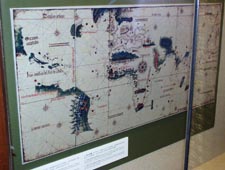 6
6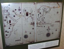 7
7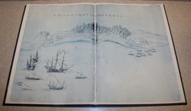
5 Chart of unknown author (circa 1502), known as "Cantino" chart showing Africa with its contours
almost correctly outlined and the coast of Brazil and the Orient still poorly defined.
[拡大画像(x19527.jpg)][拡大画像(x19528.jpg)][拡大画像(x19529.jpg)][拡大画像(x19530.jpg)]
[拡大画像(x19531.jpg)説明書き1][拡大画像(x19532.jpg):説明書き2][拡大画像(x19533.jpg): 説明書き3]
6 Portuguese chart(circa 1640)attributed to Joa~o Teixeira Albernaz, showing the Orient from the Indian Ocean to Japan, including the Philippine
Islands, the Indonesian Archipelago and the Australian coast. [拡大画像(x19534.jpg)][拡大画像(x19535.jpg)]
[拡大画像(x19536.jpg)][拡大画像(x19537.jpg)][拡大画像(x19538.jpg)][拡大画像(x19539.jpg): 説明書き1]
[拡大画像(x19540.jpg): 説明書き2]
7 [拡大画像(x19541.jpg)]
8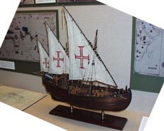 9
9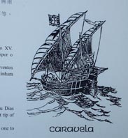
8 [英語]Latin Caravel, [西語]Carvela Latina
Latin Caravels are symbolic ships of the Portuguese discoveries in the XV century. Bartolomeu Dias commanded one of these ships when he became the first navigator to go beyond
the southernmost tip of Africa, the Cape of Good Hope. Latin Caravels were small, closed ships that sailed both before and into the wind.
They had one to three masts, Latin (triangular) sails and a tonnage of around 50 tonnes.
[拡大画像(x19542.jpg)][拡大画像(x19544.jpg)][拡大画像(x19545.jpg)][拡大画像(x19546.jpg)][拡大画像(x19547.jpg)]
[拡大画像(x19548.jpg)][拡大画像(x19549.jpg)][拡大画像(x19550.jpg)][拡大画像(x19551.jpg): 説明書き][拡大画像(x19552.jpg): 説明書き]
9 Caravela [拡大画像(x19543.jpg)]
15-16世紀の主な航海者たち
1
2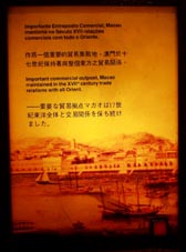 3
3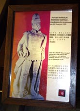 4
4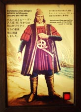 5
5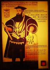
1. [拡大画像(x19621.jpg)][拡大画像(x19620.jpg)]
2. マカオは西欧と東洋との重要な貿易拠点となった。 [拡大画像(x19636.jpg)][拡大画像(x19637.jpg)]
3. 1434年ジル・イハネスがボハドル岬を迂回した。 [拡大画像(x19622.jpg)][拡大画像(x19623.jpg)]
4. バルトロミュー・ディアスは1487年から1488年にかけてアフリカ最南端に到達した。
[拡大画像(x19624.jpg)][拡大画像(x19625.jpg)]
5. バスコ・ダ・ガマは1497年から1498年にかけてヨーロッパ・東洋間の航海をはじめて成し遂げた。
[拡大画像(x19626.jpg)][拡大画像(x19627.jpg)]
6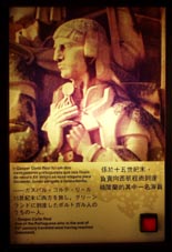 7
7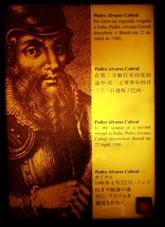 8
8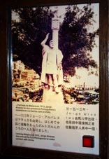 9
9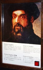
6. ガスパル・コルテ・リールは15世紀末グリーンランドに到達したポルトガル人のうちの1人。
[拡大画像(x19628.jpg)][拡大画像(x19629.jpg)]
7. カブラルは1500年4月22日、インドに向けての第二回航海においてブラジルを発見した。
[拡大画像(x19630.jpg)][拡大画像(x19631.jpg)]
8. ジョージ・アルバレスは1513年マラッカを出発、はじめて中国と接触をもったポルトガル人の1人となった。
[拡大画像(x19633.jpg)][拡大画像(x19632.jpg)]
9. 1519年マゼランは5隻の船で250人の乗組員を率いてスペインから船出した。途中フィリピンでマゼランは死亡したが、
ごく一部の生き残った乗組員がスペインまで航海を続けたどりつき、人類史上はじめて地球を周回した。
[拡大画像(x19634.jpg)][拡大画像(x19635.jpg)]
カリーニング Careening [船体を陸揚げして傾けて水線より下の船側や船底を掃除・修理すること]
1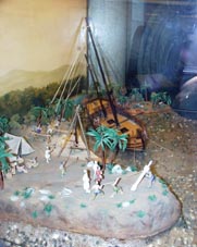 2
2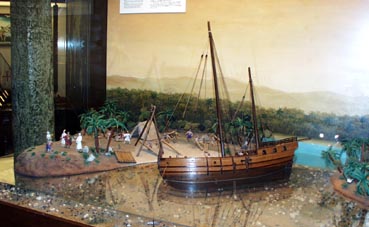
1 [拡大画像(x19638.jpg)]
2 [拡大画像(x19639.jpg)][拡大画像(x19646.jpg): 英語説明書き][拡大画像(x19647.jpg): 日本語説明書き]
*資料 [拡大画像(x19640.jpg)][拡大画像(x19641.jpg)][拡大画像(x19642.jpg)][拡大画像(x19643.jpg)]
[拡大画像(x19644.jpg)][拡大画像(x19645.jpg)]
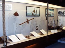
航海用具
 [拡大画像(x19478.jpg)][拡大画像(x19487.jpg)]
1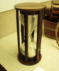 2
2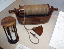 3
3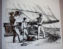
館内の英語説明書きによれば下記のように記されている。
1. [ポルトガル語]ampluheta、[英語]sand glass, an instrument used tomeasure time on board ships.
[拡大画像(x19479.jpg)][拡大画像(x19480.jpg)][拡大画像(x19488.jpg)]
[拡大画像(x19488.jpg)]
2. hand log [拡大画像(x19489.jpg)][拡大画像(x19481.jpg)][拡大画像(x19482.jpg)]
[拡大画像(x19490.jpg)]
3. 同上 [拡大画像(x19483.jpg)][拡大画像(x19484.jpg)]
[拡大画像(x19485.jpg): 説明書き][拡大画像(x19486.jpg)]
4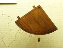 5
5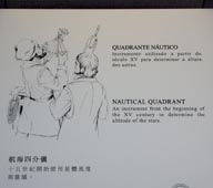 6
6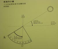
4. nautical quadrant, an instrument from the beginning of the XV century to determine the altitude of the stars
[拡大画像(x19491.jpg)]
[拡大画像(x19492.jpg)][拡大画像(x19503.jpg)]
[拡大画像(x19504.jpg)][拡大画像(x19560.jpg)]
5. 同上 [拡大画像(x19493.jpg): 図解][拡大画像(x19554.jpg): 図解]
6. 同上 [拡大画像(x19494.jpg): 図解]
7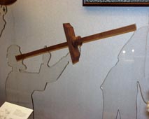 8
8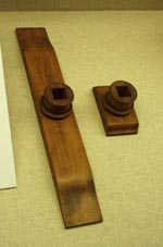 9
9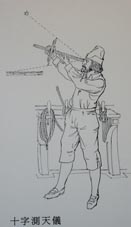 10
10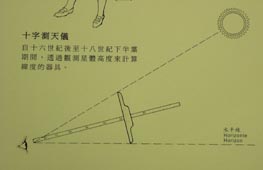
7. cross staff [拡大画像(x19497.jpg)][拡大画像(x19495.jpg)][拡大画像(x19496.jpg)][拡大画像(x19565.jpg)]
[拡大画像(x19557.jpg): 説明書き/Determining the altitude of the stars and calculating latitude]
[拡大画像(x19558.jpg): 帆船の図][拡大画像(x19559.jpg): 説明書き]
8. 同上 [拡大画像(x19498.jpg)][拡大画像(x19556.jpg)]
9. "The cross staff enabled the altitude of the stars to be determined and later the calculation of latitude.
This instrument was used from the XVI century until the second half of the XVIII."
[拡大画像(x19499.jpg)][拡大画像(x19500.jpg)][拡大画像(x19555.jpg)]
10. 同上 [拡大画像(x19501.jpg): 図解][拡大画像(x19502.jpg)]
11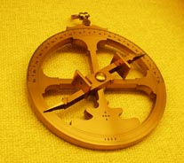 12
12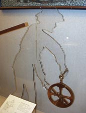 13
13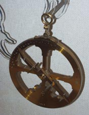 14
14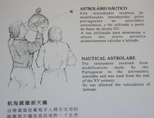
15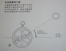 16
16
11. nautical astrolabe [拡大画像(x19505.jpg)][拡大画像(x19506.jpg)]
[拡大画像(x19509.jpg)][拡大画像(x19557.jpg)説明書き/Determining the altitude of the stars and calculating latitude]
[拡大画像(x19558.jpg): 帆船の図][拡大画像(x19559.jpg):説明書き][拡大画像(x19566.jpg)][拡大画像(x19567.jpg)]
[拡大画像(x19569.jpg)]
12. 同上 [拡大画像(x19507.jpg)][拡大画像(x19562.jpg)]
13. 同上 [拡大画像(x19508.jpg)][拡大画像(x19568.jpg)]
14. nautical astrolabe: The instrument resulted from modifications made by the Portuguese to the
astronomic astrolabe and was used from the end of the XV century. Its use allowed the calculation of latitude.
[拡大画像(x19510.jpg): 説明書き][拡大画像(x19511.jpg): 図解][拡大画像(x19563.jpg): 図解]
15. 同上 [拡大画像(x19512.jpg): 図解][拡大画像(x19564.jpg): 図解]
16. [拡大画像(x19561.jpg)][拡大画像(x19570.jpg)]
17 18
18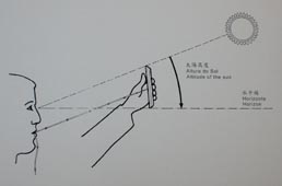 19
19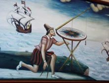
17. kamal: An instrument used by Arab navigators to measure the altitude of the stars. The Portuguese called them
Indian - boards because they first found them used by Arab pilots in the Indian Ocean. [拡大画像(x19513.jpg)]
[拡大画像(x19514.jpg)][拡大画像(x19571.jpg)]
18. [拡大画像(x19515.jpg): 図解][拡大画像(x19516.jpg): 説明書き][拡大画像(x19572.jpg): 図解]
19. [拡大画像(x19573.jpg)][拡大画像(x19574.jpg)]
20 21
21
20. 測深鉛 [拡大画像(x19578.jpg)]
21. hand lead [拡大画像(x19575.jpg): 図解][拡大画像(x19576.jpg)]
[拡大画像(x19577.jpg): 説明書き]
22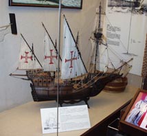 23
23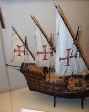 24
24
22. 横帆カラベラ船 Square-rigged caravel: These small sailing vessels, also known as a "Portuguese
Man-of-War", were mainly used in the 16th and 17th centuries. They were not only to be found in the Atlantic Ocean,
but also on the sea routes of the Orient. Their tonnage varied between 150
and 200 tonnes and their name is derived from the fact that the sails on the bow were square.
[拡大画像(x19614.jpg)][拡大画像(x19615.jpg)][拡大画像(x19618.jpg)説明書き]
23. 同上 [拡大画像(x19616.jpg)][拡大画像(x19617.jpg)]
24. 同上 [拡大画像(x19619.jpg): 図解]
 Back to: Top Page |